

Josh Subscriber
Josh Subscriber
Has any one drove the 4x4 trail from Kingsbury Grade to Spooner Summit up in Lake Tahoe by stateline on the southshore side?
Semper Fi
Has any one drove the 4x4 trail from Kingsbury Grade to Spooner Summit up in Lake Tahoe by stateline on the southshore side?
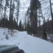
Is this the old trail that runs between So Lake Tahoe and Genoa NV?
I thought it was just a mild (though possibly washed out) dirt road?
Do you have more information?
This trail is part of the Tahoe Rim Trail. This section is 12.2 miles long according to my map. I drove the first mile then turned around. My spouse was not into it so I had to do the right thing and save the exploration trip for another day. The trail head is located of Hwy 207. You take a left off Hwy 207 onto North Benjamin street. More infomation can be found at www.tahoerimtrail.org
"Josh" wrote: This trail is part of the Tahoe Rim Trail. This section is 12.2 miles long according to my map. I drove the first mile then turned around. My spouse was not into it so I had to do the right thing and save the exploration trip for another day. The trail head is located of Hwy 207. You take a left off Hwy 207 onto North Benjamin street. More infomation can be found at http://www.tahoerimtrail.org
You sure you were on the Rim trail? As far as I know the it's is for hiking/biking/horses (depending on the section). No vehicles. Best I can tell you were here: http://www.tahoerimtrail.org/index.php? ... Itemid=209 which says:
Trail Use
This section is open to hikers, bikers and equestrians.
It looks like there are some forest roads out there, but unless I'm confused and you were on the Rim Trail, you were lucky your spouse wasn't into it. Could have been pretty expensive to get caught driving there.
Looks like it may be 14N35A or 14N32 from here:
http://www.fs.usda.gov/Internet/FSE_DOC ... 046264.pdf
http://www.fs.usda.gov/Internet/FSE_DOC ... 046262.pdf
In either case, those roads are closed until June 1 per the map but... you can get up to Genoa Peak.
It's a legal trail. I was on it last summer. Could have been a forest road I guess. It is right by this trail head.
[url] http://www.riderplanet-usa.com/atv/trai ... e_231b.htm[url]
This trail is open to ATV's, motorbikes and Jeeps. Small trail but fun with awesome views of Lake Tahoe. Did an ATV run on it today. About 4 hours to run the whole thing plus the offshoots.
It's on the Nevada side of Lake Tahoe.
Sign in to post here.