Don't Forget, meetings have moved to our new location @ Mark and Monica's Family Pizza, 4751 Manzanita Ave., Carmichael, CA 95608!


9:15 pm

January 7, 2003
 Offline


Does anybody know what the snow level is at up in the mountains? I have to work a bit on Saturday, but Sunday I was thinking of taking the family to hike up to Bassi Falls. I imagine with the warmer weather we have been having the falls should be going pretty good. Unless Bassis is higher up than I am remembering and still has lots of snow around.
9:23 pm

I think you should be fine. I'm guestimating based on google earth that Bassi is less than 5,500 feet.
10:51 pm
Club President
April 2, 2003
Offline
I believe Bassi Falls to be lower than 5500ft. 6000 is the 42mile turnoff, so this should be lower and not have much snow. There is still a couple feet at 6000ft elevation.
Kathleen and Brad
11:04 pm

May 4, 2004
Offline
The turnoff from Ice House road is pretty close to Wench Creek campground which is at approximately 4900 ft elevation.
http://www.fs.fed.us/r5/eldorado/docume ... _wench.pdf
edit) This site says 5400 ft. http://www.waterfallswest.com/.....bassi.html
2:19 am

July 15, 2005
Offline
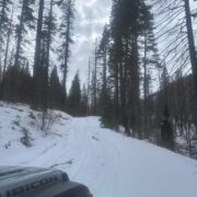
I am headed up to try and make it into the Rubicon as far as I can on Sunday. Maybe we will see you up there. What are you driving.
__________________
'If we ever forget that we're one nation under God, then we will be a nation gone under."- Ronald Reagan
3:01 am
Club President
April 2, 2003
Offline
"RobD" wrote: I am headed up to try and make it into the Rubicon as far as I can on Sunday. Maybe we will see you up there. What are you driving.
Are going to try the Wentworth entrance? We ran to Loon lake last weekend and the snow was deep where they stopped plowing just past the maintenance station. While we could get on top of the snow there, it looked dangerous to try can cross the dyke about 500 yards ahead. Take some pics if you go that way.
Kathleen and Brad
3:04 am
Club President
April 2, 2003
Offline
"FAM" wrote: The turnoff from Ice House road is pretty close to Wench Creek campground which is at approximately 4900 ft elevation.
http://www.fs.fed.us/r5/eldorado/docume ... _wench.pdf
edit) This site says 5400 ft. http://www.waterfallswest.com/.....bassi.html
The turn off to ice house road is up on top of crystal basin? I never knew bassi was so high.
Kathleen and Brad
3:15 am
January 7, 2003
Offline
Thanks for the info guys. I think we might give it a go. I will be driving a white Expedition, so if you hear one give you a honk that will be us.
3:39 am
May 4, 2004
Offline
"BKGM Jeepers" wrote: The turn off to ice house road is up on top of crystal basin? I never knew bassi was so high.
I meant the turnoff from Ice House road to the old trail head for Bassi Falls trail was close to Wench Creek campground which is said to be at 4900 feet according to the ENF website. The other site said 5400 feet which may be a little more questionable.
3:20 pm
"FAM" wrote: I meant the turnoff from Ice House road to the old trail head for Bassi Falls trail was close to Wench Creek campground which is said to be at 4900 feet according to the ENF website. The other site said 5400 feet which may be a little more questionable.
They're close in proximity, but, you have to go up hill a bit from Wench Creek to get to Bassi. My guess is that either number is close. Google Earth has a mark with Lat/Long that you can tie to an elevation. I'd imagine they're all close, but I'd lean toward the mid 5000s.
1 Guest(s)

