12:10 pm

Club Member
September 3, 2008
 Offline
7:12 pm
November 26, 2014
 Offline
9:23 pm

Club Member
August 17, 2014
 Offline
8:32 pm

Club Member
February 26, 2014
 Offline
8:35 pm

Club President
April 2, 2003
 Offline
10:34 pm
Club Member
January 20, 2009
 Offline
11:06 pm

Club President
April 2, 2003
 Offline
7:29 pm
Club Member
January 20, 2009
 Offline
8:09 pm

Club Member
August 17, 2014
 Offline
9:31 pm

Club President
April 2, 2003
 Offline
Thanks everyone!
11 rigs. More than 20 people.
We cleared about 2 miles of trail.
Lots of sawing, lopping, removing and chopping.
Justin had his power steering pump fail on the way home but the group had the right stuff to help him get back.
We ran into Kyle as well and had a good USFS chat. Youths wanting volunteer hours can gain them through some Posse/USFS trail time!
10:05 pm
April 10, 2015
 Offline
8:35 am

Club Member
August 17, 2014
 Offline
9:19 am

Club Member
February 26, 2014
 Offline
2:46 pm

Club President
April 2, 2003
 Offline
4:54 am

Club Member
August 17, 2014
 Offline
6:23 am

Club President
April 2, 2003
 Offline
10:13 am
November 26, 2014
 Offline
10:26 am
Club Member
January 20, 2009
 Offline
Jason and Tanya said
We start4ed on 11N22 and then went to 11N36. I posted pics. Only 86 this time. There's only so many pictures I can take of bushes before they all start to look alike. - Tanya
Nice pics! They say the camera adds 10 lbs but, man, how many cameras do you have on me?! Time for me to start working out again! 
1:51 pm

Club President
April 2, 2003
 Offline
Draft write up that requires picture insertion:
On Saturday, June 6th, the Gold Hills Posse 4x4 club volunteer group set off to re-open the (Insert picture of correct trail number) trail. The team consisted of 11 vehicles and approximately 24 people looking to help make an off-roading difference! To start our work day the group drove up the PacksaddlePass road until we hit 11N22, where we turned left. This trail was unpassable because of a large fallen tree (insert tree picture). While the club was clearing this tree, several people cleared the lower portion of 11N22 since we had down time (insert picture of lower work). After clearing the large fallen tree, the club moved up to our intended trail. As can be seen in this picture (insert picture of overgrown trail ) the trail required considerable clearing to make it vehicle passable. The work efforts included significant brush sawing, lopping and removal to clear the trail (insert pictures of appropriate sawing, log rolling, lopping and clearing). The end result was a trail that off road enthusiasts could navigate (insert picture of the cleared trail. Unfortunately the club was only able to clear about 2 miles of trail in the 6 hours of work we managed, requiring a follow up effort to complete the “circle” that makes the trail loop from 11N22 back to 11N22. This effort is one that the Gold Hills Posse hopes to continue throughout the summer, so we can re-open several of the many trails that are open to vehicles but no longer passable (insert a couple pictures of the vehicles on the trail that show it cleared).
Brad Bouillon
President, The Gold Hills Posse 4X4 Club
Please fill in where appropriate, and hopefully an officer can coordinate a final master that we can submit to the USFS.
1:54 pm

Club Trailmaster
March 13, 2015
 Offline
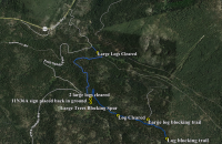
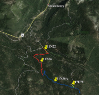
So the new GPS app I tried works ok but still not perfect. Below is as a summary of the work done by the 3 rigs that pushed ahead into the thicker brush. I was too busy getting the GPS data to work that I forgot to take any pictures.
-The blue lines in the first image indicate the extent of the trail that was run and what the GPS app recorded.
-In the second image, only the orange and most of the red lines saw complete clearing. The blue and green marked trails in the second image saw sporadic clearing where brush was thickest and logs moved.
-The 11N36 spur that continues to the south was blocked by large fallen trees.
-The 11N36A sign was pulled out of the ground. We stopped and put the sign back in. The 4x4 post is old but doesn't need to be replaced yet. If the forest service has new signs then we can put them in next time.
-Large fallen trees were removed from 11N36A ~350 ft from intersection with 11N36. Evidence of vehicles bypassing and cutting off switchback in road due to fallen trees. One of these logs had been down pretty long so it made short work of whatever sharpness was remaining in my blade.
-The 17E78 turnoff is tight due to overgrown brush and no sign is present (may be buried in the brush)
-11N36A continues past the 17E78 turnoff but is blocked by a fallen tree ~12" diameter about 1,300ft from the intersection. A narrow cut has been made to permit dirtbike passage.
-17E78 has a large and rotting fallen tree ~24" diameter about 550ft from the intersection. Evidence of vehicles leaving the trail to go around.
2:34 pm
Club Member
January 20, 2009
 Offline
3:25 pm
November 26, 2014
 Offline
3:41 pm

Club President
April 2, 2003
 Offline
kris_olof said
So the new GPS app I tried works ok but still not perfect. Below is as a summary of the work done by the 3 rigs that pushed ahead into the thicker brush. I was too busy getting the GPS data to work that I forgot to take any pictures.
-The blue lines in the first image indicate the extent of the trail that was run and what the GPS app recorded.
-In the second image, only the orange and most of the red lines saw complete clearing. The blue and green marked trails in the second image saw sporadic clearing where brush was thickest and logs moved.
-The 11N36 spur that continues to the south was blocked by large fallen trees.
-The 11N36A sign was pulled out of the ground. We stopped and put the sign back in. The 4x4 post is old but doesn't need to be replaced yet. If the forest service has new signs then we can put them in next time.
-Large fallen trees were removed from 11N36A ~350 ft from intersection with 11N36. Evidence of vehicles bypassing and cutting off switchback in road due to fallen trees. One of these logs had been down pretty long so it made short work of whatever sharpness was remaining in my blade.
-The 17E78 turnoff is tight due to overgrown brush and no sign is present (may be buried in the brush)
-11N36A continues past the 17E78 turnoff but is blocked by a fallen tree ~12" diameter about 1,300ft from the intersection. A narrow cut has been made to permit dirtbike passage.
-17E78 has a large and rotting fallen tree ~24" diameter about 550ft from the intersection. Evidence of vehicles leaving the trail to go around.
Excellent information and pictures everyone!
My hope is that we can argue 11N36 actually continues to the 17E78 split, and that 11N36A actually begins past that turn off. This way we may be able to label the entire loop as 11N36. That would be the easiest to argue once it's cleared and Kyle can go up there to verify it.
8:37 pm

Club Member
August 17, 2014
 Offline
Tan
k-jeep said
Jason and Tanya said
We start4ed on 11N22 and then went to 11N36. I posted pics. Only 86 this time. There's only so many pictures I can take of bushes before they all start to look alike. - Tanya
Nice pics! They say the camera adds 10 lbs but, man, how many cameras do you have on me?! Time for me to start working out again!
Tanya.... Sweetheart... Um... Can we talk about a few "angles" you've taken of certain workers bending ???
8:55 pm

Club President
April 2, 2003
 Offline
No love lost in this group!!
Seriously however. I think we can all agree that this was a big effort! I wanted to gauge the group's interest in the next phase of this work. How many people would be up for (veteran workers and newbies alike) a shot at finishing this loop? I think we should set an earlier cut off time, and move up to some of the higher trails. I think several of them may be "quick fixes" compared to the one we bit off initially. What does everyone think? I don't have any date or timeline in mind. I'm just gauging interest.
1 Guest(s)


 I'm glad everyone made it home.

