Don't Forget, meetings have moved to our new location @ Mark and Monica's Family Pizza, 4751 Manzanita Ave., Carmichael, CA 95608!


11:45 am
Club Trailmaster
March 13, 2015
 Offline


Starting at Sierra Trek and again at the toy drive I ended up having conversations with some of the operators of Post Wildfire OHV Recovery Alliance (PWORA) and they have approached us to restore Strawberry ASAP rather than wait on the Forest Service to Figure things out. This seems like a no-brainer to me as using all volunteers means it gets fixed at least a year ahead of any Forest Service led project and we get a much bigger seat at the table. If anyone has ant issues with this plan please post up or PM the officers with any concerns.
Attached is the draft Document PWORA sent to start this process. I think the document is good but lacks the necessary detail so I pulled out my mapping info I took from the last Patrol.
Attached is my first draft map of previously existing obstacles, optional new obstacle/bypass locations due to dozer excess, basic areas of repair, and campsite formalization.


In summary we need to draft a narrative description of each obstacle/area/repair/modification and justify it. After Spur A I don't seem to have as many obstacles as I remember their being so please dig into your phones and look for photos and text them to me. If you text them then I should get the geocoding location your phone recorded when the phone took the picture.
Here is an example of the language in my document to expand their work:
"Point 1 – North Gatekeeper
A common method of controlling access to a trail that not any car can access is by use of a “gatekeeper”. This obstacle, whether natural or artificial, should represent the general trail difficulty and give uninformed users the ability to experience the difficulty of the trail combined with the easy ability to turn around where a typical tow truck will have access or at least easy ability to hike out to pickup and cell service. There are significant examples of gatekeepers being removed that have led to net negatives for a trail including the gate keeper on El Dorado County’s own Rubicon. Given the usage of hunters in deer season taking bone stock full-size trucks where they shouldn’t, the replacement of the gatekeepers should be step 1.
The North Strawberry Gatekeeper used to consist of a smooth dome shaped boulder approximately 8ft in diameter and 3ft tall on the right side of the trail. The left side of the trail was level with the top of the boulder with a curving, V-shaped trench between the left side of the trail and center of the boulder. Shortly above the boulder was a smaller series of 1ft tall rocks that served to show potential users that difficulty did not decrease after the gatekeeper.
This gatekeeper would be re-established using rocks onsite to for example, a stock full-size truck from getting through without difficulty. Additionally a short explanation of the trail difficulty would be added to the North end info board saying something to the effect of 'If you have trouble with the gatekeeper then expect trouble with the rest of the trail'"
Please also post up similar explanations of obstacles you remember and photos if you have them.
8:19 pm

Club Member
January 19, 2011
Offline
Interesting proposal Kris. That for sharing the information. It’s a good idea.
Semper Fi
7:00 am
Club Member
August 17, 2014
Offline
Yes, interesting proposition & due to the snow up there, we have plenty of time to get together & discuss this in more detail. Maybe separate meetings aside from the regular monthly meetings for those than can get the time to do so.
I agree with plan to start with recommendations on the north gate keeper, adding the south gate keeper (near where the gate was) to restrict the ease of entry on both ends. In between could be "phase 2". I'll check our past photos & see what we have to contribute. There may be some online videos that can be used as well.
11:21 am

Club Member
July 10, 2003
Offline
I'm good with gatekeepers but also like the idea of easy and hard line options. New gatekeepers are too easy to tear apart, and it will happen as that trail is popular with hunters. As much as I'd like to think that people will let the new obstacles settle, more than likely they will tear them down. So, an easy line and hard line option will make for less frustration and work in the future. Just my two cents... carry on.
I used to wheel a lot. . .
12:26 pm
August 16, 2021
Offline
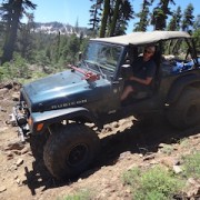
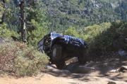
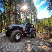
I have been using this trail for 20 years and even before the fire it was not as hard as it once was. The pinch rock usta claim a tail light from almost ever group I went with back in 02-04. It was rearranged some in 05ish to make it less likely to cause damage but keep it a formidable obstacle. I know it was moved again a few years back to basically eliminate it as an obstacle. After that I could take my stock-definitely-not-a-rock-crawler jeep commander through it. To my mind opening pinch rock up made for a "better" trail because it became consistent rather than one obstacle that was much harder than the rest of the trail. I am aware that some don't share that view.
As it stands, today I'm not sure it needs much of a gatekeeper because it would be accessible by the hunter in a stock 4x4. I have been through there a few times since the fire in my stockish jeep truck (bad break-over and exit angles) and I have not encountered anything I would call an obstacle for that vehicle. I would take a stock f150 through there in fair weather... Maybe even a two wheel drive. A few spots would be obstacles in that hypothetical vehicle and would take some care but its doable in my mind.
Maybe you guys already have this, I see the map showing obstacles, but it seems to me you need to have a plan for how hard the entire trail will be going forward before you can properly "size" a gatekeeper. In other words are the gatekeepers being proposed trying to keep hunters/non-wheelers out or are they trying to set precedence for the trail as it is now or are they trying to set precedence for a future post-fire version of the trail? Maybe all it needs is one of those cute little jeep signs on each end.
Mark ~ KJ6EUO
12:48 pm
Club Member
July 14, 2016
Offline
It might make sense to work trail restoration from the middle out, restoring the gatekeepers after restoring the less technical sections of the trail. This would make it easier to get vehicles and equipment in to work on mitigation efforts farther inside the trail. Where is the equipment and funding coming from for this project?
Jeff and Kathy Root
7:49 am
Club Member
August 17, 2014
Offline
JohnDF said
I'm good with gatekeepers but also like the idea of easy and hard line options. New gatekeepers are too easy to tear apart, and it will happen as that trail is popular with hunters. As much as I'd like to think that people will let the new obstacles settle, more than likely they will tear them down. So, an easy line and hard line option will make for less frustration and work in the future. Just my two cents... carry on.
That a true statement John, they will get torn apart, unless some heavy equipment can move something that can't be easily moved. We did try to move rocks in one spot, using Dale's 12KLB winch & it was torn down. I guess we'll have to see what kind of funding the Forest Service is willing to spend on improvements before we do much future planning.
8:14 am

January 20, 2009
Offline
Jeff_R said
It might make sense to work trail restoration from the middle out, restoring the gatekeepers after restoring the less technical sections of the trail. This would make it easier to get vehicles and equipment in to work on mitigation efforts farther inside the trail. Where is the equipment and funding coming from for this project?
I was thinking the same thing. Getting a small/medium backhoe up there would be a huge help to making obstacles that can’t be torn apart.
Kevin
11:41 am
Club Trailmaster
March 13, 2015
Offline
Jeff_R said
Where is the equipment and funding coming from for this project?
PWORA will bring their SWECO trail dozer and a bunch of volunteers, I will bring my mini-excavator (9k). I will verify with PWORA but outside of diesel and food for the volunteers, there shouldn't be any significant costs. In past projects, PWORA has applied for grants from the greensticker fund as well as received corporate donations.
8:09 am
Club Member
September 3, 2008
Offline
I would love to help. Any idea when we will have potential dates?
As with several other members, this trail has a lot of meaning to some of us. I would love to get it back to it's glory.
Um...what?
9:52 am
Club Trailmaster
March 13, 2015
Offline
Gregulator said
I would love to help. Any idea when we will have potential dates?As with several other members, this trail has a lot of meaning to some of us. I would love to get it back to it's glory.
No dates yet, this would be mid summer to late summer depending on the forest service approvals.
1 Guest(s)

